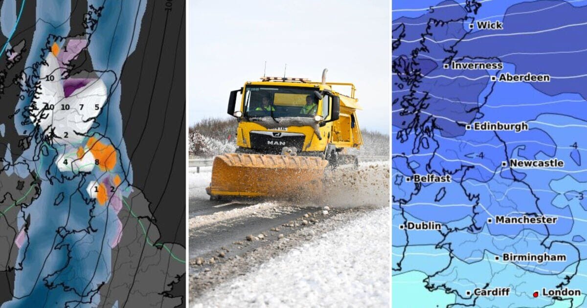
A 36-hour snow storm will hit the British Isles (Image: WX Charts)
Weather maps have turned white and purple for the hours leading up to Christmas, as a 36-hour snow storm is set to hit parts of Britain.
Live WX Charts’ graphs shows that between 6pm on December 23 and 6am on Christmas morning, flurries of snow will constantly fall over at least some parts of the British Isles. Incredible, the rare phenomenon of freezing rain – which turns rain into ice the moment it hits the ground – is also predicted for a large area over the north of England on December 24.
On Christmas Eve, the entirety of the north of Scotland – everywhere higher than Edinburgh, will be hit by wintery weather, while it will travel further south to the Scottish Borders and Dumfries and Galloway by 12 noon.
By Christmas Day, it is expected to hit as far south as the Midlands. On Christmas Eve, 10cm of snowfall an hour is expected in the north and west of Scotland, while 1cm of snow could fall in the north west of England. An area just north of Birmingham will also see snow lie on the ground.
On Boxing Day, however, the snow will disappear across most parts, and instead there will be a 300-mile rain bomb hitting over the west coast of Scotland and the Western Isles, with rainfall also hitting south Wales, Plymouth and East Anglia.
READ MORE: UK snow update as new weather map shows 400-mile snowstorm hours before Xmas [LATEST]

Cold air will sweep over the UK (Image: WX Charts)
The north and west of Scotland will still have accumulated snowfall by this point, though, with the Met Office predicting that snow and sleet is “likely”, particularly on higher ground throughout this time period.
However, the national forecast does not issue precise forecasts for snow more than a few days in advance.
Separate cold weather maps show that on December 22, temperatures will plummet as low as -6C in Stirlingshire as a brutal Scandinavian blast grips the nation.
Elsewhere, the mercury will plunge to -5C on Scotland’s north coast, -4C in Inverness and -1C in Aberdeen. Further south, it will hit -4C in Edinburgh, 0C in Newcastle, -1C in the north of England and 0C in Wales.
Not even the south of England will escape colder temperatures, with temperatures of 2C around London, 3C in Plymouth and highs of 5C in East Anglia.

Temperatures will plunge to -6C before the cold snap (Image: WX Charts)
In its long-range forecast for the hours immediately before Christmas and heading into the New Year warns that “sleet and snow” is expected at times, with a “risk of frost and fog”.
It reads: “Mainly unsettled conditions appear likely for most, with spells of wind and rain followed by showers affecting most areas but especially the north and northwest of the UK.
“Some sleet and snow is also likely at times, especially on high ground in the north. However, there are also some signs that more settled conditions are possible at times, these perhaps most likely across the south late in December or into early January.
“Temperatures are likely to be around average overall, with any more settled interludes bringing a risk of frost and fog.”

Snow will blast into Scotland on Christmas Eve (Image: WX Charts)
Met Office five-day forecast
Tuesday, December 10 until Saturday, December 14
Headline:
Frost and fog overnight with mostly dry conditions.
Today:
Cloud cover persists in England and Wales, with showers gradually retreating to the south coast. Northern Ireland and Scotland will enjoy drier weather with sunny intervals, despite morning frost and fog.
A chillier feel today with less windy conditions than of late.
Tonight:
England, Wales and Shetland will see extensive cloud cover with occasional scattered showers. Patchy freezing fog is set to return for Scotland and Northern Ireland, with widespread frost under prolonged clear spells.
Wednesday:
Another predominantly dry day, save for a few isolated showers in the far southeast. Generally cloudy, though brighter spells are expected in the north and west.
Cold temperatures, particularly where fog remains.
Outlook for Thursday to Saturday:
High pressure continues to hold sway, delivering fine weather with some sunshine and overnight frost and fog. Blustery showers in the south will dissipate, with sporadic rain appearing in the north later.


