

THE TAKEAWAY
- Mid-South and Midwest face heavy rain, strong wind gusts and potential flash flooding on Election Day.
- States of Emergency remain in effect across the Southwest, where widespread flooding still lingers.
- The massive system will reach the East Coast Thursday and is expected to have impacted more than 35 states and 120 million people by the end of the week.
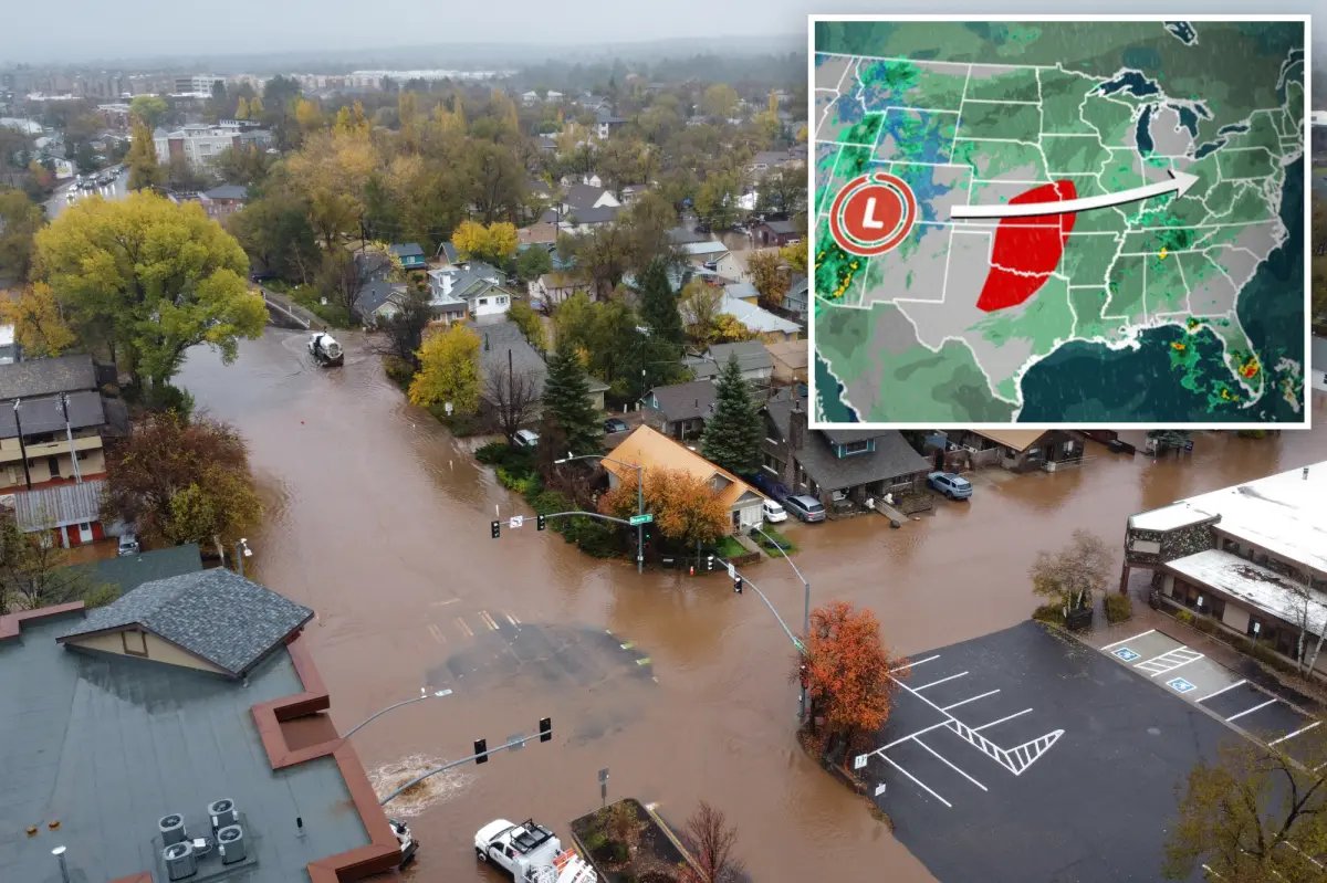
A powerful cross-country storm that caused widespread flooding across the Four Corners region is moving through the Central U.S., bringing heavy rain and the potential for severe thunderstorms and flash flooding across the Mid-South and Midwest on Election Day, with more than 35 states and 120 million people expected to be affected by the system by the end of the week.
Police in Flagstaff, Arizona, said a man was found dead Monday after he was seen being swept into floodwaters over the weekend.
As the system pushes east, southern portions of the Mississippi River and Tennessee valleys will see periods of heavy rain through the day with an isolated tornado threat beginning in the afternoon, while parts of the Midwest will see heavy rain and strong wind gusts throughout the day into Wednesday.
Widespread rain is forecast to reach the Mid-Atlantic and the Northeast by Thursday.
Southwest: Dangerous flooding sweeps across the region
The storm brought heavy rain to parts of the Southwest and Four Corners region, including Arizona, southern Utah, northwestern New Mexico and southwestern Colorado, where flooding inundated several communities.
Some rivers in Arizona, New Mexico and Colorado reached record-high levels, with some that are still cresting.
In response to the widespread flooding, Gov. Katie Hobbs declared a statewide state of emergency Monday to unlock critical funding and state resources for Arizona communities impacted by the recent storms.
States of emergency were also declared in Utah and Colorado, with significant flooding still lingering along the San Juan River. The flooding in those communities has prompted polling site changes and other Election Day accommodations across both states.
Rain was not the only concern across the Southwest. While lower elevations dealt with heavy rainfall and flooding, colder air moving into the region brought snow to higher elevations.
The highest elevations of the San Juan, Sawatch, Wasatch and Uinta ranges received more than a foot of wet, heavy snow. Southwest Colorado’s mountain passes saw between 12 and 18 inches, while other high-elevation areas received 4 to 10 inches.
Plains & Mid-South:
Severe thunderstorms raced across the Southern Plains Monday, slamming parts of Oklahoma with 60 mph wind gusts.
Storms will race across the South through the day, bringing the threat of damaging winds and a few tornadoes to parts of Louisiana, Mississippi, Arkansas and Alabama.
In addition to the severe weather threat, 1 to 2 inches of rain are expected, with localized amounts of 2 to 3 inches possible. This could lead to isolated instances of flash flooding.
A Level 2 out of 4 flash flood risk remains in effect through Tuesday night across northern Mississippi and southwestern Tennessee, including Memphis.
On Wednesday, a Level 1 out of 4 flash flood threat covers parts of Tennessee and the Ohio Valley.
Midwest: Heavy rain and gusty winds target the region
Heavy rain is expected to spread across Missouri, Iowa, Nebraska, Illinois, Minnesota and Wisconsin Tuesday.
According to the FOX Forecast Center, wind gusts of 40 to 50 mph are possible from eastern Kansas and Nebraska through Iowa, Minnesota and Wisconsin.
The strong winds could create hazardous travel conditions and lead to potential delays.
Many locations could receive 1 to 2 inches of rain or more, the FOX Forecast Center said.
Widespread severe flooding is not currently expected, but periods of heavy rain could lead to localized flooding in Omaha, Des Moines and Minneapolis.
East Coast: Heavy rain moves east, ending dry streak
The storm will move toward the Great Lakes and Mid-Atlantic by midweek before tracking toward the Northeast, where heavy rain is expected to impact the region.
Rain should begin spreading into the Ohio Valley on Wednesday before reaching the I-95 corridor around Thursday or Friday.
Widespread rainfall totals of more than an inch are possible across the Northeast, with localized amounts approaching 2 inches from central Pennsylvania and Maryland through the New York City area and southern New England.
The rain could help ease dry conditions but downpours could cause minor flooding across the region.
Several areas are experiencing their longest dry stretches of the year so far, with New York City, Boston and Philadelphia all going more than two weeks without rainfall.
As well, drought conditions remain a concern across parts of New England, particularly in Maine, where the entire state is experiencing some level of drought.
Although heavy rain is expected, it is likely it will not make a dent in the ongoing drought.
